Shinjuku City Outline
Emblem, Flower and Tree of Shinjuku of City
City Emblem (Established in March, 1967)
This emblem has at its base, a rhombus-shaped form that is said to depict reliability from ancient times, upon which the initial character of Shinjuku 「新」 or Shin is written in one stroke in a dynamic fashion, depicting the city’s will to grow even more steadily into the future.
Shinjuku City Flower (Established in October 1972)
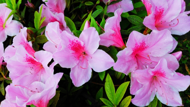
Azalea
Okubo-dori Avenue was a famous spot for azaleas from the Edo period until the early Showa period. There was a time when extra trains were operated simply for the purpose of viewing them.
Shinjuku City Tree (Established in October, 1972)
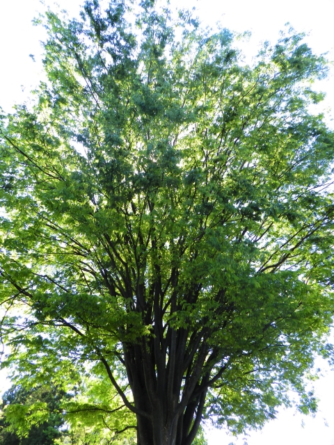
Keyaki (Zelkova Tree)
Keyaki (Zelkova trees) are representative trees from the Musashino area. It is one of the trees that can be seen the most in Shinjuku City.
Location and Area of Land
Shinjuku City is located almost at the center of the 23 cities of Tokyo and lies adjacent to the cities of Chiyoda, Minato, Bunkyo, Toshima, Nakano, and Shibuya. The Shinjuku City Office Main Building (1-4-1 Kabuki-cho) lies at Lat. 35°41’ 26” N and Long. 139° 42’ 23” E. The city covers 18.22 sq. km of land, stretching across about 6.5 km from east to west and about 6.3 km from north to south, with a perimeter of about 29.4 km. The city is 13th in size among the 23 cities of Tokyo. (Including the mouth of the Ara-kawa River and the central breakwater landfill area, the total area of land of the 23 cities of Tokyo is 627.53 sq. km.)
Population
Geographic Features
Since the shape of the land consists of plateaus and lowlands, the city can be divided into the following: the Toshima Plateau area, the Yodobashi Plateau area and the Shitamachi Lowland area. The Toshima and Yodobashi Plateau areas include the plateau areas of Yotsuya, Ushigome, Tsunohazu, Kashiwagi, Okubo, Totsuka, and Ochiai, while between each of these plateaus are the Shitamachi Lowland area.
The land peak within the city is Hakone Hill in Tokyo Municipal Toyama Park, where the altitude is 44.6m. The plateau areas have an average altitude of 30m, while the lowest altitude in the low-lying areas is in the Iidabashi area at 4.2m. By comparison, the altitude of Shinjuku City Office is 32.55m. The geological layers of the plateau area from the surface consist of the loamy layer of the Kanto Plain, the Musashino sand layer and the Tokyo layer. The geological layers of the lowland area consist of alluvium and the Tokyo layer. Both the Plateau and Lowland areas there is Miura layer underneath the Tokyo layer.
The City Name
In the year after the start of the shogun government in Edo (1603), five major avenues were designated with Nihon-bashi Bridge as the starting point. These were Tokaido Avenue, Nakasendo Avenue, Nikko-kaido Avenue, Oshu-kaido Avenue and Koshu-kaido Avenue. Inns were placed along each avenue, and the inns were obliged to provide horse messenger services.
Koshu-kaido Avenue was the main road from Nihon-bashi Bridge to Kofu, and from Kofu connected to Shimo-Suwa via the Nakasendo Avenue. Nihon-bashi Bridge was a long way from the first inn area—Takaido —on the Koshu-kaido Avenue, and travelers had a difficult time making the trip. For this reason, upon the request of Lord Takamatsu Kiroku , authorization was received to place an inn in an area midway. Since the inn was placed on the property of Lord Naito, who returned this land to the Shogun government, and since the inn was new, the area was called Naito-Shinjuku (Naito new inn), thus marking the origin of the name Shinjuku for the area.
On March 15, 1947, the three areas of former Yotsuya, Ushigome, and Yodobashi cities merged to create Shinjuku City. The name Shinjuku was used not only because of its historical significance, but also because Shinjuku Gyoen National Garden and Shinjuku Station were well known across Japan.
The History of the Names of the Three Areas of Shinjuku City
Yotsuya: Originally, a bleak part of the Musashino Plains, the area where Yotsuya Yonchome Intersection is today used to be a single road with nothing but deep thickets and valleys on either side. Then, four teahouses where travelers could rest were established. It is said that the name Yotsuya as we know it today with the characters for “four valleys” evolved from the name Yotsuya with the characters for “four shops.”
Ushigome: The word kome means to be crowded, and it is said that this name came about because long ago, there were many cows put out to graze in this area. Lord Ogo of the State of Kozuke (what is now Gumma Prefecture) came to live in this area, and called himself Ushigome in 1555. Lord Ushigome was affiliated with Lord Hojo of Odawara, and owned the land from Ushigome to Hibiya, and the castle was located on the plateau of the Fukuro-machi area. The grave of Lord Ushigome is still located in Sosan-ji Temple (1 Benten-cho).
Yodobashi: It is said that the name of the bridge crossing over the Kanda-gawa River that flowed between Naruko-mura and Nakano-mura evolved from being called Yodo- (extra) or Yodokoro- (four places) Bashi (bridge). It is also said that when the third shogun, Tokugawa Iemitsu, was resting by the bridge during the Kan-ei period (1624–1644), he thought that the flow of the river seemed to be almost stagnant (yodomu), and decided to call the bridge Yodobashi. There is also a story that the eighth shogun, Tokugawa Yoshimune, named the bridge Yodobashi around 1720 to 1730 because the scenery reminded him of Yodo in the State of Yamashiro (what is now Kyoto). There are also various other stories, all of which seem to explain how the name of the area evolved from the name of the bridge.